Hydro-Meteorology
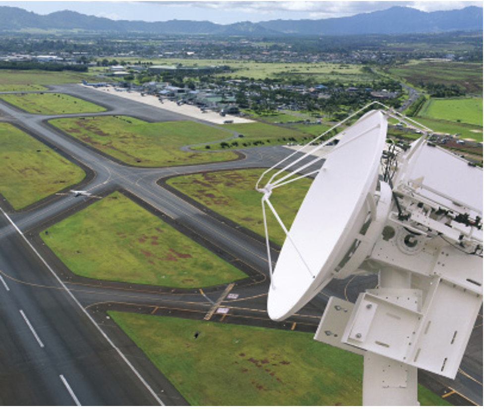
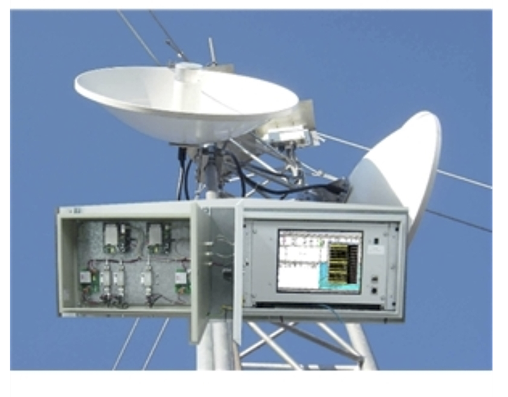
Weather Radars
S Band Radars
Defender S SERIES FROM EEC
The Power to Predict
With the ultimate long-range view, the EEC S-Band radar gives you the ability to plan, predict and protect – before severe weather strikes. This massive power makes our S-Band systems ideal for covering huge expanses of land and water, analyzing multiple fronts of heavy precipitation.
Big Weather Needs A Big Radar
Monsoons. Hurricanes. Cyclones. Blizzards. To make the best long-range predictions of the biggest weather makers, you need to have the biggest radar with the lowest attenuation. Both the Magnetron-powered and Klystron-powered Defender S series are designed and engineered with an output of 850kW to 1000kW - more radiated power than any other commercially available S-Band weather radar! Coupled with our super-sensitive IQ2 digital receiver and signal processor for precise data processing, these towering S-Band systems are the best choice for a clean and true picture of multiple, long-range, intense weather phenomena. Additionally, our turnkey design, manufacturing, and installation processes allow us to configure your S-Band radars to meet your specifications. Among the many options are single or dual-polarity transmitters and a variety of full-featured control and display systems. You can even choose the type of installation and radome that best fits your environmental needs.
Dual-Polarization – The Future Is Here Today
Over 15 years ago, EEC pioneered dual-polarity radar. Today, both of our S-Band models are available with either EEC's industry-standard single-polarization or with our new, highly advanced dual-polarization system, incorporating features that are years ahead of anything else on the market. Working with world-renowned experts and the University of Oklahoma, we have developed better algorithms and end-to-end dual-polarization measurements. This not only results in more accurate estimates of rainfall, but also provides better discrimination between different types of precipitation and non-meteorological signals, such as birds, insects, dust storms, or even an approaching tornado's debris field. We have also developed proprietary technology to significantly improve clutter suppression performance in our popular and dependable Magnetron systems.

DEFENDER S SERIES ADVANTAGES
- Systems are available in Magnetron and Klystron transmitter configurations.
- Algorithms developed and specifically tuned for performance at S-Band.
- Superior performance designed for long range weather detection.
- Innovative architecture provides highest receiver sensitivity.
- Advanced radar motion control system provides better spatial resolution resulting in more accurate data.
- Industry leading clutter suppression technology.
- Patented fiber-optic technology provides noise free, ultra-high speed data throughput.
- Adaptive spectrum-based clutter mitigation algorithms.
- Improved data quality achieved through advanced continuous calibration techniques.
- Advanced Polarimetric rainfall estimation and attenuation correction techniques.
- Over 500 configurable diagnostic points monitored in real-time.
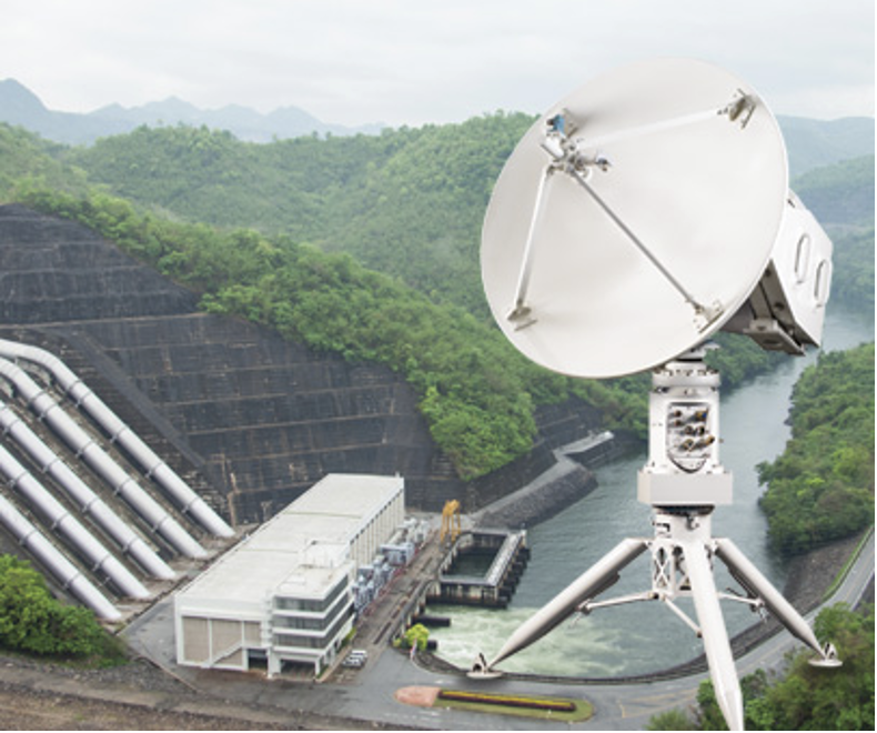
C Band Radars
ENDURANCE C-BAND SYSTEMS FROM EEC
The solid-state of things to come
EEC is proud to introduce Endurance C, our fully solid-state C-Band radar product line. Endurance C systems provide for ultra-wideband performance and low life-cycle costs thanks to advanced solid-state power amplifiers operating in the widest C-Band frequency range available. For geographic areas with diverse and dynamic weather conditions, nothing offers greater return on your investment than the Endurance C.
The Benchmark Standard Around The World
For most areas of the world, nothing offers a better value than the proven line-up of C-Band radar systems from EEC. Even in challenging environments, our C-Band systems provide powerful and accurate information. Perhaps most importantly, the specifications of our C-Band radars can be customized to meet a wide range of demands and uses.
ENDURANCE C:
EEC’s solid-state Endurance C-Band radars are the most advanced weather radar systems in the world. Thanks to their perfect balance of power and effective range, these systems are the ideal choice for customers with a diverse set of weather detection demands. You can choose to equip them in either single or dual-polarity configurations.With any EEC C-Band radar, our turn-key design, manufacturing, and installation processes allow us to configure your system to your exact specifications. Among the many options are single or dual-polarity transmitters and a variety of full-featured control and display systems. For a clean and true picture of mid to long range weather events, we will match your EEC C-Band system with the precise Doppler processing of our super-sensitive IQ2 signal processor and digital receiver. You can even choose the installation and radome that best fits your environmental needs.
DEFENDER C-Band SERIES FROM EEC
The Global Choice for Protection:
For geographic areas with diverse and dynamic weather conditions, nothing offers greater value for the money than EEC's line-up of popular Defender Series C-Band weather radars. The choice of weather services, national governments, broadcasters, and businesses around the world, EEC can custom configure a C-Band solution for almost every need.
The Benchmark Standard Around The World.
For most areas of the world, nothing offers a better value than the proven line-up of C-Band radar systems from EEC. Even in challenging environments, our C-Band systems provide powerful and accurate information. Perhaps most importantly, the specifications of our C-Band radars can be customized to meet a wide range of demands and uses.
DEFENDER C250, CK250, C350:
With years of innovation and refinement behind them, the EEC 250kW and 350kW C-Band radars are now among the most popular radars in the world. Thanks to their perfect balance of power and effective range, these systems have evolved to become the ideal choice for customers with a diverse set of weather detection demands. You can choose to equip them with either reliable magnetrons or klystrons and in either single or dual-polarity configurations.
DEFENDER C500:
The idea behind the ingenious Defender C500 is simple: If 250kW is the most popular, most practical single-pole configuration; then the best configuration for dual-polarity applications should be 250kW of power delivered in both the horizontal and vertical plane. Developed specifically for the most effective dual-polarization performance, this 500kW magnetron system is the radar for both today’s needs and tomorrow’s technology.
DEFENDER C1000:
The most powerful C-Band in use, with an incredible 1MW of power, the Defender C1000 is the choice of local and national TV broadcasters looking for that extra edge in weather detection. Utilizing this powerful system broadcasters can now detect, depict and warn viewers of approaching severe weather while providing a dramatic and visually stunning data display.

ENDURANCE C SERIES ADVANTAGES
- Systems come standard with a fully solid-state transmitter.
- Reduced life-cycle maintenance costs thanks to no reliance on consumable magnetron or klystron tubes.
- Ultra-wideband performance from 5200-5900 MHz virtually removes any risk of frequency interference.
- Hot-swapping of solid-state power amplifiers means no system downtime during transmitter maintenance.
- Safe, low voltage solid-state power amplifiers provide no high voltages to endanger technicians and preventative maintenance engineers.
- Algorithms developed and specifically tuned for performance at C-Band.
- Designed for high-resolution medium to long range weather detection.
- Innovative architecture provides the highest receiver sensitivity.
- Advanced radar motion control system provides better spatial resolution resulting in more accurate data.
- Industry leading clutter suppression technology.
- Patented fiber-optic technology provides noise free, ultra-high speed data throughput.

DEFENDER C SERIES ADVANTAGES
- Systems are available in Magnetron and Klystron transmitter configurations.
- Algorithms developed and specifically tuned for performance at C-band.
- Designed for high-resolution medium to long range weather detection.
- Innovative architecture provides the highest receiver sensitivity.
- Advanced radar motion control system provides better spatial resolution resulting in more accurate data.
- Patented fiber-optic technology provides noise free, ultra-high speed data throughput.
- Adaptive spectrum-based clutter mitigation algorithms.
- Improved data quality achieved through advanced continuous calibration techniques.
- Advanced Polarimetric rainfall estimation and attenuation correction techniques.
- Super-high resolution IQ2 16-bit digital signal-processor.
- Over 500 configurable diagnostic points monitored in real-time.
- Systems configured with IQ data recording and playback.
- Flexible configuration options that maximize available bandwidth on any standard TCP/IP network..
- Comprehensive suite of radar data exchange protocols.
X Band Radars
DEFENDER X-Band SERIES FROM EEC
The Perfect, Practical, Precise Solution
EEC’s Defender X-Band weather radar system is ideal for short and medium applications that require any combination of accuracy, mobility, and of course, reliability.
For Short To Mid-Range Accuracy, X Marks The Spot
EEC's shorter wavelength X-Band weather radar can detect even tiny particles, such as high altitude water droplets or light snow. The compact size of this complete X-Band system makes it the perfect choice for portable applications and "filling-in" geographical areas that S-Band and C-Band skip over. Dual-polarity capabilities are standard features for this system.
DEFENDER X200:
Powering its 200kW output with dependable magnetron technology, EEC’s Defender X200 is the accurate and reliable workhorse of X-Band; used all over the world for mobile research and in permanent installations. Configuring a Defender X200 system to your exact specifications is simplified with our turn-key design, manufacturing, and installation processes. Our many options include a variety of full-featured control and display systems, and precise data processing through our super-sensitive IQ2 digital receiver and signal processor.
Dual-Polarization – The Future is Here Today
Over 15 years ago, EEC pioneered dual-polarity radar. Today, our Defender X200 radar comes with a new, highly advanced dual-polarization system incorporating features that are years ahead of anything else on the market. Working with world-renowned experts and the University of Oklahoma, we have developed better algorithms and end-to-end dual-polarization measurements. This not only results in more accurate estimates of rainfall, but also provides better discrimination between different types of precipitation and non-meteorological signals such as birds, insects, dust storms, or even the debris field of an approaching tornado. We have also developed proprietary technology to significantly improve clutter suppression performance in our popular and dependable Magnetron systems. The final result is obvious – EEC dual-polarization systems provide the best weather detection capability in the industry today.
X-Band RANGER NEW Solid State SERIES FROM EEC
This is the Future of X-Band
The new era of X-Band is here! Everything you want in an X-Band is in EEC's new Ranger weather radar system. The Ranger system features dual-polarity accuracy, solid-state transmitters, and low power consumption, all in one affordable and portable unit.
Put The Accuracy Of Dual-Polarity To Work Anywhere
Operating on the shorter X-Band wavelength, EEC's Ranger weather radars have dual-polarity built-in so they can detect even tiny particles, such as high altitude water droplets or light snow at short to mid-range distances. The Ranger's compact size means you can install it in a hard-to-reach permanent location or take it almost anywhere, anytime as a truly portable unit. And with a very affordable price, EEC's new Ranger is the ideal solution for everything from small airports to offshore oil platforms to rapid deployment military maneuvers.
THE RANGER-X1 & X5:
This is what X-Band should be! Developed by EEC in collaboration with the prestigious Advanced Radar Research Center at the University of Oklahoma, the affordable Ranger-X1 is a compact system weighing less than 430 lbs/195kg yet featuring a 100-watt dual-polarity, advanced solid-state transmitter and very low power consumption. Whether you choose the Ranger-X1 or Ranger-X5 with more radiated power, EEC's turnkey design, manufacturing, and installation processes allow us to configure your system to your exact specifications. Among the many options are a variety of full-featured control and display systems, and precise Doppler processing through our super-sensitive digital receivers. You can even choose permanent or mobile installation options.
DEFENDER X SERIES ADVANTAGES
- Algorithms developed and specifically tuned for performance at X-Band.
- Designed for fixed-site and transportable configurations.
- High resolution data optimized for short and medium range weather detection.
- Innovative architecture provides the highest receiver sensitivity.
- Advanced radar motion control system provides better spatial resolution resulting in more accurate data.
- Industry leading clutter suppression technology
- Patented fiber-optic technology provides noise free, ultra-high speed data throughput.
- Adaptive spectrum-based clutter mitigation algorithms.
- Improved data quality achieved through advanced continuous calibration techniques.
- Advanced Polarimetric rainfall estimation and attenuation correction techniques.
- Super-high resolution IQ2 16-bit digital signal-processor.
- Over 500 configurable diagnostic points monitored in real-time.
- Systems configured with IQ data recording and playback.
RANGER SYSTEM ADVANTAGES
- Algorithms developed and specifically tuned for performance at X-Band.
- Advanced technologies in a compact and light-weight design.
- Ultra high resolution data for short and medium range weather detection.
- Designed for fixed installations or rapid mobile deployment.
- Allows for simultaneous or alternating dual-polarization modes.
- High availability.
- Simplified design removes complex wave guide and switches.
- Decreased system power consumption.
- The most efficient pulse compression techniques available.
- Super-high resolution IQ2 16-bit digital signal-processor.
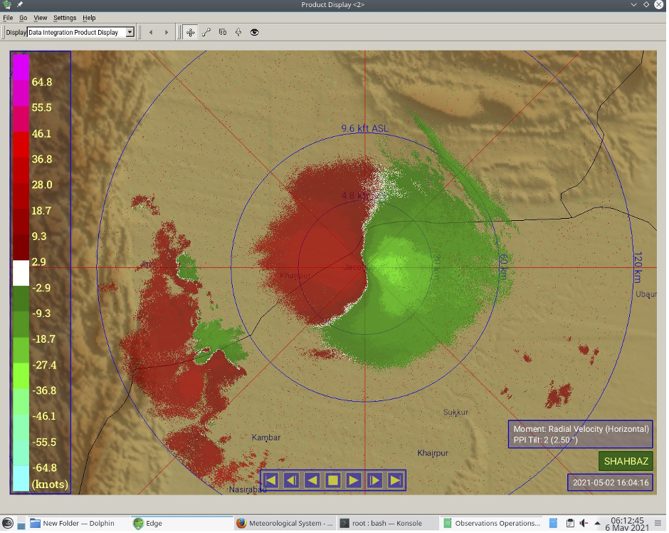
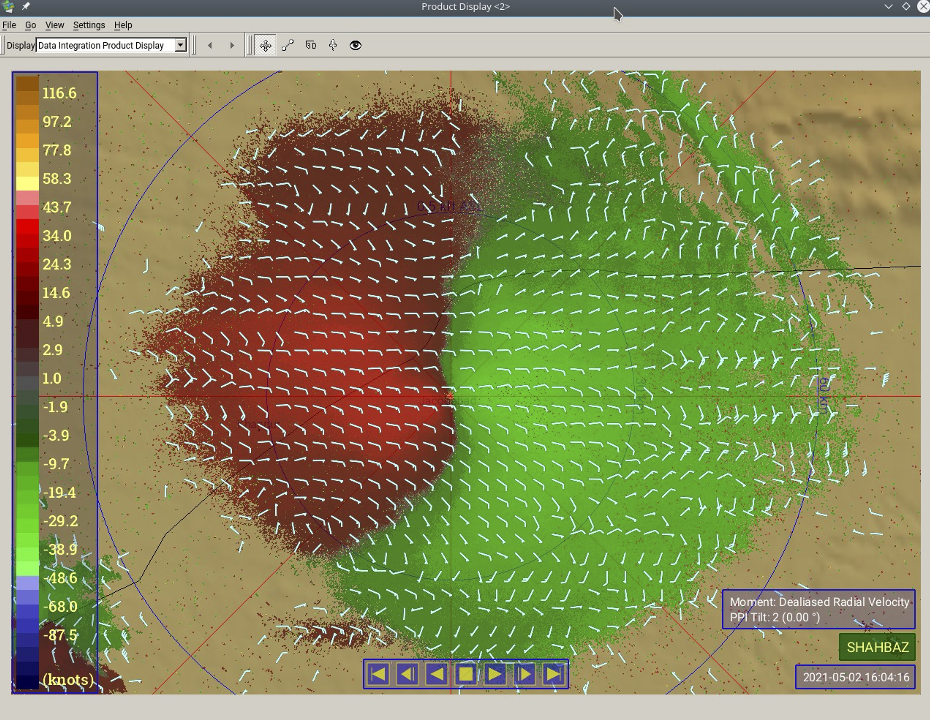
Radar Software
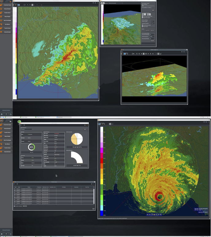
EDGE Radar Analysis Software from EEC
Software That Puts You in Control
Making it easy to extract, display, and interpret useful weather information in ways that you never thought possible - that's the whole idea behind our powerful suite of weather radar control and data display software.
Powerful Tools Give You New Ways to Look at the Weather
When you take control of EEC's display software, you have the power to easily do what you have always wanted to do: observe and interpret phenomena previously hidden within the data. Set alerts to automatically warn when certain conditions are detected. Animate and manipulate data to compare different "what-if" scenarios. Organize and retrieve all of your information through a built-in database management system. Plus many more sophisticated meteorological products. Our software is both powerful and easy to use because, like all of our other products, it is designed and created by EEC's own engineers. Since it interfaces seamlessly with our processors and displays, our engineers can build in the most powerful and comprehensive set of features for weather analysis possible – even include custom algorithms tuned for each radar band we manufacture. With unmatched flexibility and ease of use, an entire suite of specialized products, and seamless integration into all EEC systems, our display software puts you in control.
Pulse Radar Analysis Software from EEC
OUR WEATHER ANALYTICS & VISUALIZATION
Making it easy to extract, display, and interpret useful weather information in ways that you never thought possible - that’s the whole idea behind our powerful suite of weather radar control and data display software.
Powerful Tools Give You New Ways To Look At The Weather
When you take control of EEC’s display software, you have the power to easily observe and interpret phenomena previously hidden within the data, set alerts to automatically warn when certain conditions are detected, animate and manipulate data to compare different “what if” scenarios, organize and retrieve all of your information through a built-in database management system, and many other sophisticated meteorological tasks. EEC’s software suite is both powerful and easy to use because, like all of our other products, it was designed and created by EEC’s own engineers. Since it interfaces seamlessly with our processors and displays, our engineers built in the most powerful and comprehensive set of features for weather analysis possible – including custom algorithms tuned for each radar band we manufacture. EEC’s analysis and visualization software suite puts you in control with unmatched flexibility and ease of use, and seamless integration into all EEC systems.
EDGE software, EEC’s new analysis and visualization software ADVANTAGES
- Modernized look-and-feel with user-selectable window themes.
- All LINUX OS controls are hidden by default, so the user logs into a simpler and cleaner interface.
- Standard User Groups, such as "Forecaster" and "Maintenance", with available controls limited to typical use cases (configured by an Administrator).
- A single display for all products, with improved layer controls.
- Dynamic topographic maps, where the resolution adapts to the displayed area.
- Improved vector layers, such as showing differing road types and road signs that do not change with zoom level.
- Improved event logs with better filtering.
- Enhanced web server, with higher quality maps, basic radar controls, and improved support for smaller devices (e.g. smart phones).
- Ability to save commonly-used windows and data selections and restore them quickly on a per-user basis.
- Auto and manual backup of configuration with restore capability.
Seismology
Accelerometer
AC-2x Accelerometer
Product Description
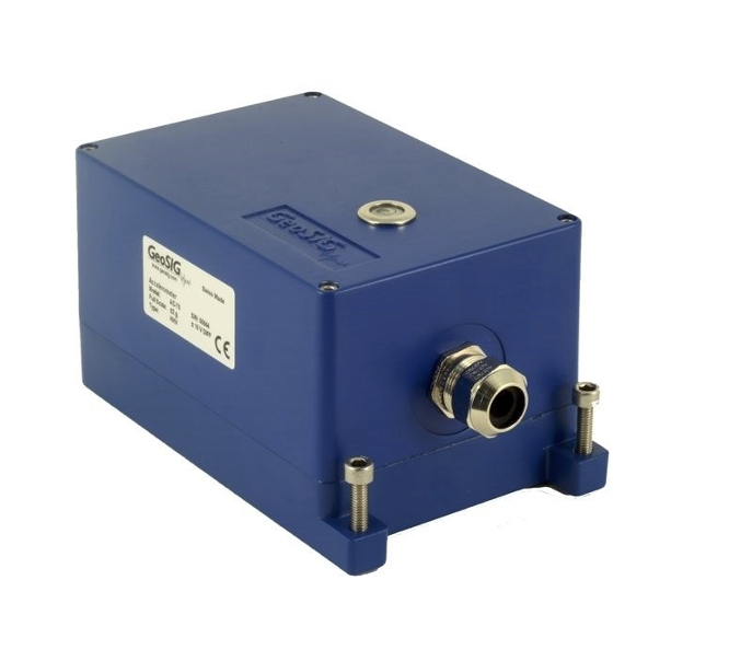
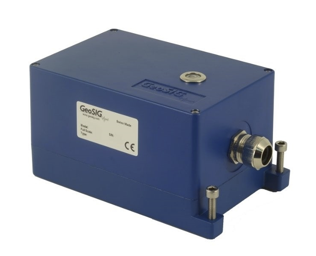
The AC-23 package is a triaxial accelerometer sensor designed for Strong Motion and industrial applications where a high sensitivity is required. The AC-2x series are state-of-the-art servo-accelerometers based on standard exploration geophone mass-spring system with electronic feedback. Having remarkable temperature and aging stability because of the very simple principle, the AC-2x rarely requires maintenance.
Triaxial, biaxial and uniaxial configurations are all available in surface models, complementing the versatile useability of the AC-2x.
The AC-2x is housed in a sealed cast aluminium housing with the dimensions of 195 x 112 x 95 mm. The housing also offers a single bolt mounting system with three levelling screws. Stainless steel housings as well as internal mounting inside GSR-xxAH housing options are available. With the help of the TEST LINE the sensor can be easily and completely tested. Full scale is user selectable on site by setting the internal jumpers. The AC-2x accelerometer is directly compatible with the GeoSIG recorders.
Key Features
- Full Scale ± 0.1, 0.2, 0.5, 1, 2 and 4g jumper selectable (NPP: ± 0.5, ± 1 and ± 2g Full Scale).
- Bandwidth 0.1 Hz to 100 Hz (optional 200 Hz).
- Excellent temperature stability.
- Strong-Motion, Free field and Industrial applications.
- Different housing and mounting options are available.
- Single Bolt Mounted Enclosure provides up to ± 10° of Levelling Adjustment.
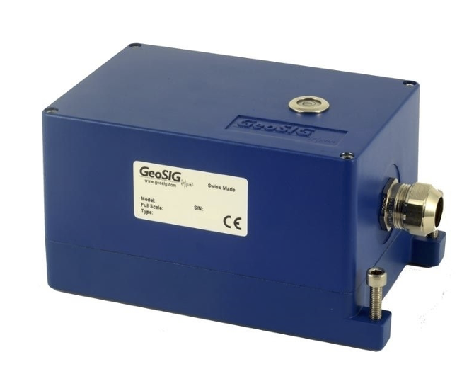
AC-4x Accelerometer
Product Description
The AC-43 sensor package is a triaxial accelerometer designed for urban and industrial applications regarding strong motion earthquake survey and vibration monitoring as well as alarm and switch systems. All these applications require rugged sensors with minimum maintenance and a simple method for periodic testing.
The AC-4x accelerometer is based on the modern MEMS (Micro Electro-Mechanical Systems) technology, consisting of sensing cells assembled in a way that optimizes their performances. This combined with the state of the art proprietary circuit design yields this cost effective and reliable accelerometer. MEMS cells include linear accelerometer sensing elements which measure the capacitance variation in response to any movement or inclination and a factory trimmed interface chip that converts the capacitance variations into analog or digital signal proportional to the motion.
TThe DC response allows the sensor to be easily repaired, tilt tested or recalibrated in the field. With the help of the TEST LINE, the AC-4x accelerometer can be completely tested assuring proper operation. The AC-4x is typically housed in the standard GeoSIG sealed cast aluminum housing with dimensions of 195 x 112 x 95 mm. The housing also incorporates a single bolt mount with three levelling screws. Stainless steel packaging options are available. The AC-4x accelerometer is directly compatible with the GeoSIG recorders. It is also designed to be mounted internally in standard GeoSIG recorders.
Key Features
- Full Scale: ± 2 g (± 0.625, 1, 4, 5 g optional).
- Bandwidth DC to 100 Hz.
- MEMS Accelerometer.
- High accelerations measurement.
- High shock survivability.
- Large temperature range.
- High lifetime stability.
- Cost effective sensor.
- Low power consumption.
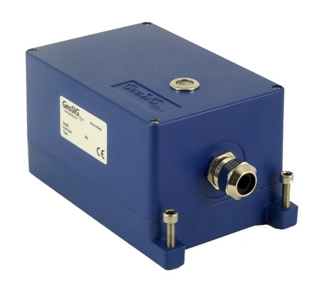
AC-7x Accelerometer
Product Description
The AC-73 sensor package is a true electro-mechanical triaxial downhole accelerometer designed for broadband earthquake monitoring and applications requiring highly sensitive and rugged sensors with minimum maintenance and a simple method for periodic testing.
The rugged mass suspension moving coil system improves the signal to noise ratio. The magnetic system and capacitive position sensors offer symmetrical controls for the accurate electronic centering of the mass. At rest, the accelerometer mechanism is in balance and no electrical output is generated.
In case of a ground motion, AC-73 yields an electrical output proportional to the current used to keep the mass centered. This output signal is precisely calibrated to provide a signal at the utmost accuracy and with a lowest possible noise level. The symmetrical positioning system incorporated with the force balance accelerometer principle, the accelerometer faithfully keeps its scaling and calibration even under extreme conditions.
The DC response allows the sensor to be easily repaired, tilt tested or recalibrated in the field. With the help of the test line the AC-73 accelerometer can be completely tested assuring proper operation and accurate acceleration measurement. This test line is internally connected to the external world only when a given command is sent to the sensor to avoid any noise pick-up through the test input.
Key Features
- True Electro-mechanical.
- Force Balance Accelerometer.
- Digital AC-73D version available.
- Dynamic Range 165 dB.
- User selectable Full Scale range.
- ± 0.5, 1, 2, 3 or 4 g.
- Bandwidth from DC to 200 Hz.
- Exemplary Offset stability.
- Temperature and drift compensation.
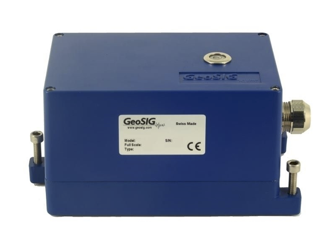
AC-7x-DH Accelerometer
Product Description
The AC-73-DH sensor package is a true electro-mechanical triaxial downhole accelerometer designed for broadband earthquake monitoring and applications requiring highly sensitive and rugged sensors with minimum maintenance and a simple method for periodic testing. The rugged mass suspension moving coil system improves the signal to noise ratio. The magnetic system and capacitive position sensors offer symmetrical controls for the accurate electronic centring of the mass. At rest the accelerometer mechanism is in balance and no electrical output is generated.
In case of a ground motion, AC-73-DH yields an electrical output proportional to the current used to keep the mass centred. This output signal is precisely calibrated to provide a signal at the utmost accuracy and with a lowest possible noise level. The symmetrical positioning system incorporated with the force balance accelerometer principle, the accelerometer faithfully keeps its scaling and calibration even under extreme conditions. The DC response allows the sensor to be easily repaired, tilt tested or recalibrated in the field. With the help of the test line the AC-73-DH accelerometer can be completely tested assuring proper operation and accurate acceleration measurement. This test line is internally connected to the external world only when a given command is sent to the sensor to avoid any noise pick-up through the test input.
Key Features
- True Electro-mechanical Force Balance Accelerometer.
- Extremely robust downhole housing.
- Suitable for borehole diameters of 100 mm and larger.
- Dynamic Range 165 dB.
- Full Scale ± 0.5, 1, 2, 3 or 4 g.
- Bandwidth from DC to 200 Hz.
- Temperature and drift compensation.
- Robust suspension system.
- Proprietary iSensor™ interface.
Seismometer
Arolla - VE series - Broadband Seismometer
Product Description
Designed and handmade in Switzerland, arolla broadband seismometer is the culmination of years of experience designing high precision, low noise, and reliable seismic equipment.
arolla’s versatile, compact, lightweight, and rugged design, make it an ideal choice for many applications and use cases.
From the beginning, the design goals for the arolla broadband seismometer were to make the most accurate, most reliable, easy to use/deploy, and consistent quality sensor on the market. Its triaxial design, wide temperature range, low temperature sensitivity, magnetic shielding, precision factory calibration of the sensor response, and robustness help to achieve these goals and beyond.
The introduction of arolla marks the launch of a new series of seismometers by GeoSIG, which will be complemented with further exciting products.
arolla will also be available in a posthole version.Typical applications include study of local, regional, and teleseismic events; national seismic networks; Earth mode observations; site surveys; and more.
Key Features
- Precision calibration of sensor response.
- Flat response from 120 seconds to 50 Hz.
- Automatic leveling and mass centering; remote mass centering available.
- No mass locking needed.
- Electromagnetic shielding.
- Corrosion resistant and robust housing.
VE-1x Velocity Sensor
Product Description
The VE Velocity Sensors are engineered for consistent performance over a long lifetime. Advanced computerized testing, manufacturing techniques and quality control are used in the production process to provide both, the uniform parameters and the rugged qualities required in modern velocity sensors.
The sensor module has proven itself successfully world-wide for many years in different applications. The symmetrical rotating dual coil construction minimizes the force on the spring arms. The use of precious metals ensure optimum electrical contact and a long operating life. The VE Velocity Sensors operate from a wide range of input voltages and can be used for a variety of civil engineering and general vibration measurement applications.
The VE-11-H is uniaxial horizontal, the VE-11-V uniaxial vertical, VE-12 biaxial and the VE-13 is a triaxial velocity sensor. The VE Velocity Sensors are housed in a very compact 195 x 112 x 95 mm case. The sealed cast aluminum housing contains a MS style connector or a sealed cable inlet. The housing also incorporates a single bolt mount with three levelling screws, which offers extended adjusting capability during mounting.
Key Features
- Wide Full Scale Range, ± 1 to ± 100 mm/s.
- Bandwidth 1 Hz to 315 Hz.
- Built-in Impulse Test Circuit.
- No mass locking needed.
- Electromagnetic shielding.
- Single Bolt Mounted Housing provides up to ± 10° of Levelling Adjustment.
VE-2x Velocity Sensor
Product Description
The VE Velocity Sensors are engineered for consistent performance over a long lifetime. Advanced computerized testing, manufacturing techniques and quality control are used in the production process to provide both, the uniform parameters and the rugged qualities necessary in modern velocity sensors. The sensor module has been proven world-wide for many years in different applications. The symmetrical rotating dual coil construction minimizes the force on the spring arms. The use of precious metals ensures optimum electrical contact and a long operating life.
The VE Velocity Sensors operate from a wide range of input voltages and can be used for a variety of civil engineering and general vibration measurement applications. The VE-21-H is uniaxial horizontal, the VE-21-H a uniaxial vertical and the VE-23 is a triaxial velocity sensor. The VE Velocity Sensors are housed in a very compact 195 x 112 x 95 mm case. The sealed cast aluminum housing contains a MS style connector or a sealed cable inlet. The housing also incorporates a single bolt mount with three levelling screws.
Key Features
- Wide Full Scale Range, ± 1 to ± 100 mm/s.
- Bandwidth 4.5 Hz to 315 Hz.
- Civil Engineering and general vibration measurement applications.
- Built-in Impulse Test Circuit.
- Single Bolt Mounted Housing provides up to ± 10° of Levelling Adjustment.
VE-3x Velocity Sensor
Product Description
The VE Velocity Sensors are engineered for consistent performance over a long lifetime. Advanced computerized testing, manufacturing techniques and quality control are used in the production process to provide both, the uniform parameters and the rugged qualities required in modern velocity sensors. The sensor module has proven itself successfully world-wide for many years in different applications. The symmetrical rotating dual coil construction minimizes the force on the spring arms. The use of precious metals ensure optimum electrical contact and a long operating life.
The VE Velocity Sensors has its 3 dB at 4.5 Hz and can be used for a variety of civil engineering and general vibration measurement applications. The VE-31-H is uniaxial horizontal, the VE-31-V uniaxial vertical, VE-32 biaxial and the VE-33 is a triaxial velocity sensor. The VE Velocity Sensors are housed in a very compact 195 x 112 x 95 mm case. The sealed cast aluminum housing contains a MS style connector or a sealed cable inlet. The housing also incorporates a single bolt mount with three levelling screws, which offers extended adjusting capability during mounting.
Key Features
- Sensitivity G 27.3 Vs/m.
- Bandwidth 4.5 Hz to 315 Hz.
- Civil Engineering and general vibration measurement applications.
- Single Bolt Mounted Housing provides up to ± 10° of levelling adjustment.
- Surface and Wall mount.
- Temperature compensated.
- Downhole Version (VE-3x-DH) is also available.
VE-5x Seismometer
Product Description
The VE-5x is a triaxial short period seismometer designed for seismic monitoring applications.
The VE-5x seismometer is based on a state of the art geophone mass-spring system with electronic feedback. It is ideally suited for installation in vaults with low to moderate noise.
VE-5x offers a remarkable stability under temperature fluctuations or against aging. In addition, due to the innovative design of the unit no mass locking is required.
The VE-5x is housed in a sealed cast aluminum housing. The housing incorporates a single bolt mounting system with three levelling screws.
The broader band version, VE-53-BB, is suitable for applications involving an extended frequency range.
Stainless steel or Ex-proof packaging options and a downhole version, VE-53-DH, are also available.
The VE-5x seismometer is directly compatible with all GeoSIG solutions.
Key Features
- Sensitivity 1000 V/m/s differential.
- Bandwidth 1.1 s (0.9 Hz) to 89 Hz 8.0 s (0.125 Hz) to 160 Hz (BB version).
- Dynamic Range > 125 dB (0.9 - 15 Hz) > 120 dB (0.9 - 30 Hz).
- Robust mechanical design.
- Excellent temperature and aging stability.
- Low power consumption.
- Easy testing, low maintenance.
Recorders / Digitisers
Standard
Ela - GMS series
Product Description
Ela is the state-of-the-art accelerograph designed for large scale deployment for indoor and outdoor installations. It is a pedigree of GeoSIG's flagship GMS series of recorders with more than 10 years of proven field test for reliability and high performance.
Its compact and robust purpose-built design allows ela to be used as part of a large deployment for EEW. It can stream real-time data and record with multiple filtering options and embedded adjustable triggering algorithms, making it an asset in damage estimation and disaster management.
ela is a cost-effective solution, yet still effective for many sensitive applications where flexibility in data manipulation is a serious demand.
State-of-health data can be transmitted at user configurable intervals to a data center for management and maintenance purposes. ela's many customizable features and its attractive price point — without sacrificing reliability or quality — make it ideal for large scale deployment. ela is fully compatible with existing GeoSIG sensors and can co-exist and co-perform in the same network as the GMS series recorders.
Key Features
- Based on GMS flagship technology.
- Fast and easy setup and deployment.
- Floor or wall mount with automatic offset compensation.
- Power over Ethernet (PoE).
- Alarm relays* for auto-shutdown.
- Wi-Fi* connectivity.
- Time synchronization via NTP or GNSS* (GPS, BeiDou and GLONASS).
Scai - GMS series
Product Description
GeoSIG's latest offering— scai (pronounced /skaI/, like the sky above and named after a Swiss peak, Piz Scai)—is the groundbreaking latest generation of the GeoSIG Measuring Systems with highest performance, excellent operational flexibility and enhanced connectivity. With its optimized installation, operation and maintenance philosophy, scai offers an abundance of features and options. Its user-replaceable modular electronic boards make scai extremely maintainable and future-proof.
It includes an Ethernet connection and optionally a Wi-Fi (b/g/n) module to ensure fast and reliable data transfer. Both wired and wireless network interfaces can be used simultaneously. Its design and efficiency make it the first choice for any application requiring seismic instruments. Highly reduced cost of ownership and user-friendly approach in the design make scai the perfect choice for the most advanced user. Numerous optimizations within the architecture and the design yields unprecedented performance for seamless and fast execution of all system processes.
Key Features
- Modular electronics for field repair and upgrade.
- 3 or 6* channels, up to 2000 sps sampling rate.
- Low noise individual 24-bit Δ−Σ ADC per channel.
- Internal built-in and/or external sensor options.
- Wired, Wi-Fi*, GSM*, satellite* links.
- Power-Over-Ethernet and wide power range.
- Smart satellite* or network timing.
Nair - GMS series
Product Description
GeoSIG's latest seismic recorder offering— nair (rhymes with fire, named after Swiss peak Piz Nair)—is the groundbreaking latest generation of the GeoSIG Measuring Systems with highest performance, excellent operational flexibility and enhanced connectivity. With its optimized installation, operation and maintenance philosophy, nair offers an abundance of features and options. Its user-replaceable modular electronic boards make nair extremely maintainable and future-proof.
It includes an Ethernet connection and optionally a Wi-Fi (b/g/n) module to ensure fast and reliable data transfer. Both wired and wireless network interfaces can be used simultaneously. Its design and efficiency make it ideal for any application requiring seismic instruments. It boasts an impressive 147db (0.02-20Hz), making it suitable for weak-motion precision recording as well. Numerous optimizations within the architecture and the design yields unprecedented performance for seamless and fast execution of all system processes.
Key Features
- Modular electronics for field repair and upgrade.
- 3 or 6* channels, up to 5000* sps sampling rate.
- Low noise individual 32-bit Δ−Σ ADC per channel.
- Internal built-in and/or external sensor options.
- Wired, Wi-Fi*, GSM*, satellite* links.
- Power-Over-Ethernet and wide power range.
- USB for storage and communication devices*.
GMSplus - GMSplus6
Product Description
GMSplus is the ground breaking late generation of the GeoSIG Measuring Systems with high performance, excellent operational flexibility and enhanced connectivity. The unit is based on the GMS technology of NetQuakes Seismographs, which are developed in close coordination with USGS, and deployed in high quantities in North America establishing the NetQuakes network.
It includes an Ethernet connection and optionally a Wi-Fi (b/g/n) module to ensure fast and reliable data transfer. Both wired and wireless network interfaces can be used simultaneously. Its design and efficiency makes it the first choice for any application requiring seismic instruments. With its optimized installation, operation and maintenance philosophy, the GMSplus offers the real possibility to implement high-density arrays with total costs at a small fraction of conventional strong-motion seismograph networks.
The instrument’s software processes data in real time. If triggered by a seismic event, GMSplus calculates a number of Event Parameters and reports them to a data centre immediately. GMSplus is a self-contained instrument and is equipped with an uninterruptible power-supply, which provides more than 24 hours autonomy.
Key Features
- Second generation of NetQuakes Recorder.
- 3 or 6 channels, up to 1000 sps sampling rate* up to 15 channels using digital sensors.
- Low noise individual 24-bit Δ−Σ ADC per channel.
- Internal built-in and/or external sensors.
- Wired Ethernet, Wi-Fi** and Serial links.
- Smart NTP timing, GPS time base, or time synchronization via radio channel or cable.
- Enhanced connectivity via landline modems, 3G cellular devices and satellite links.
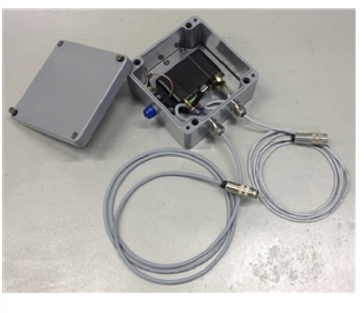
Digital Sensor System
Product Description
GeoSIG Digital Sensor System has been developed to accommodate the requirements for a cost effective and practical installation in circumstances where several measuring points need to be deployed over long distances.
The system consists of GMSplusD recorder and AC-7xD or AC-4xD digital accelerometers, with the option of adding analogue sensors. Each digital accelerometer transfers its data digitally, accurately and effectively to the GMSplusD through a single cost effective Cat5E cable.
It is possible to connect up to 4 digital accelerometers (AC-7xD / AC-4xD) to a GMSplusD with a total length of 1’000 meters.
Additionally internal or external analogue sensors can be connected to the same GMSplusD to increase the number of monitored channels to 15.
Key Features
- High expandability .
- Up to 15 channels thru 3 analogue and 12 digital inputs.
- Easy and low cost installation.
- Real-time data conversion and processing.
- Acceleration, velocity and displacement.
- Low and Highpass filtering, decimation.
- 500’000 hours MTBF obtained from real field statistics.
GMS NetQuakes Recorder
Product Description
The GMS is the ground breaking second generation of the GeoSIG Measuring Systems with extended connectivity capability and flexibility. The unit is developed in close coordination with USGS and deployed in high quantities in North America establishing the NetQuakes system.
It includes an Ethernet connection and optionally a 2.4 GHz Wi-Fi module to insure fast and reliable data transfer. Its design and efficiency makes it the first choice for any application requiring seismic instruments.
With its optimized installation, operation and maintenance philosophy, the GMS offers the real possibility to implement such as high density arrays with total operating costs at a small fraction of conventional strong-motion seismograph networks.
The instrument’s software processes data in real time. If triggered by a seismic event, GMS calculates Peak Ground Acceleration (PGA), Peak Ground Velocity (PGV), Peak Ground Displacement (PGD) and Response Spectrum (RSA) at various frequencies of the event.
GMS can report these parameters, which are related to the strength of shaking, to a data center where a synopsis (such as a shakemap) for disaster management facilities can be generated in almost real time over the Internet.
An event file is also recorded in the memory, which is sent out from the instrument and also securely accessible over the Internet.
Key Features
- NetQuakes Recorder .
- Internet Enabled, Optionally Wireless, Multifunctional Measuring System.
- > 130 dB, 3 or 6 channels, up to 500 SPS.
- Linux Operating System with On Board Processing and Evaluation .
- Timing via NTP (Network Time Protocol), Optional GPS or 433 MHz Wi-Synch.
- Enhanced Connectivity Options for GSM, GPRS, Satellite, Radio Telemetry or Landline Modem, Wired/Wireless Network.
- Data Stream Output, Network Triggering.
Central/Multichannel
SMS / SAS
Product Description
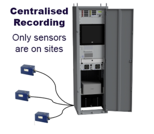
The SMS/SAS systems are mostly used in Nuclear Power Plant or other Industrial Facility Seismic Monitoring Projects. If you need any further specific information, please do not hesitate to contact us through our agent assigned for this kind of instrumentation for your geographical region or directly.
The core of the SMS / SAS is a Central Processing Unit (CPU) with a multi-channel digital recorder system rack mounted in an industrial cabinet together with an industrial computer and relevant peripherals. Accelerometers, seismometers, complete seismic stations or sensor packages, which are referred to as Detection / Recording Units (DRUs), are placed at remote locations and can be connected to the CPU.
The system has been designed in a way that it is not bound to a single topology. There could be only the sensors or both sensors and data acquisition out in the field. Advantages of these topologies are briefly explained in the specifications section.
The system has great modularity and flexibility to simplify an instrumentation upgrade and enable existing elements to be reused as much as possible. The system provides added reliability with built-in redundancy of the recorders and power supply, continual SOH software checks, alerts transmitted to multiple sources, and a choice of data back-up. The PSU has quadruple redundancy of the sources. All calculations take place on each recorder, so the PC (CPU) has no critical impact on calculation and analysis of exceedances.
The CPU monitors all DRUs in parallel, as a result of the dedicated communication links that are provided by the system hardware.
By monitoring continuously the DRUs, the CPU detects seismic events, generates associated alarms and automatically processes the recorded data. Also it performs periodical tests on the system and monitors the system-wide state of the health as well as analyses the detailed cause of any malfunction.
Key Features
- Recording, advanced analysis and annunciation according to project specific or international regulations.
- Automatic exceedance evaluation.
- Reporting and alerting via relays, visual and audible tools as well as printed matter.
- Project specific Automatic Event Processing (AEP), Nuclear (NPP) or other features.
- Up to 36 remote triaxial analog sensors and unlimited number of seismic field recorder stations.
- 24 to 32-bit event based and/or continuous recording.
- Common timing and triggering within the system .
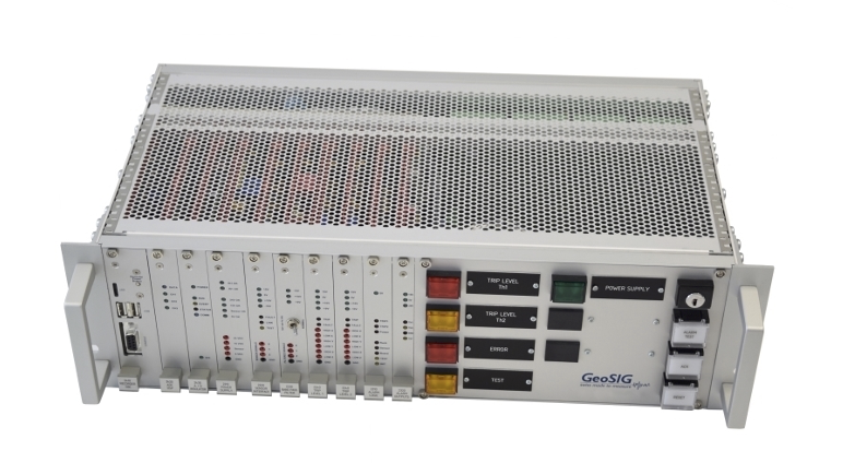
STS
Product Description
STS is a state-of-the-art seismic switch / trip system packaged as a 19’’ rack module consisting of Slot-in Modules (SiMs) inserted into vertical slots with a remote accelerometer connected to it. It provides a set of highly reliable alarm contacts as outputs activated by exceedance of acceleration and/or based on state of health.
The STS combines the best of the analog and digital technologies by utilising only hardware for the highly reliable alarms, and digital data acquisition for realtime digital monitoring, recording, playback, in-depth processing and archiving of the sensor signal. The unit provides full traceability of the sensor signal as well as the system logs, even if no trip was activated; with a buffer spanning to several weeks back. All of the digital information can also be provided to remote users in real time, on demand, continuously and/or periodically.
Key Features
- High reliability by using only analog signal and hardware for the trip signal.
- Field proven GeoSIG accelerometer.
- Trip on any individual sensor axis or on any vector sum of axes.
- Highly flexible analog filtering for the sensor signal to fit project requirements.
- Testable analog full chain from sensor up to alarm output.
- Permanent monitoring of the connection to the sensor.
- Easy maintenance and simple troubleshooting with rich number of test points and indicators.
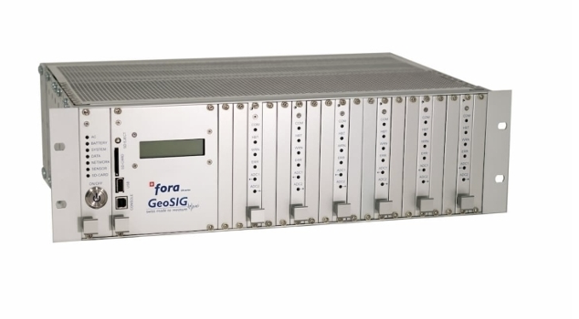
Fora - CR series
Product Description
GeoSIG's latest offering in central data acquisition systems is fora, our most advanced multichannel central monitoring and recording system. fora — part of the CR series — is a 19" rack module with Slot-in Modules (SiMs) inserted into vertical slots, and it features an extremely flexible 24 Bit (or optionally 36 Bit) multichannel recorder. It has up to 36 channels, and by combining several fora systems, hundreds of channels can be monitored. Data from acceleration, velocity, displacement, strain, meteorological or any other type of sensors can be monitored and recorded with superior data quality.
There is true simultaneous sampling with the shared clock for up to 36 channels, and fora's capable of communication via Ethernet TCP/IP, internal landline modem*, external GMS modem*, external satellite modem*, external GPRS modem*, or external UMTS/3G modem*.
Key Features
- Unlimited number of channels by combining 36 channel modules.
- Dynamic range - 137 dB, 150 dB*.
- Individual D-S ADC per channel - 24-bit, 32-bit*.
- Adjustable sampling rates up to 2000 sps, 5000 sps*.
- True simultaneous sampling with shared clock for up to 36 channels.
- Internal Fast SSD hard drive up to 1TB with SATA interface and high storage capacity. Mirroring function on SD card* or USB drive*.
- Built-in display for easy inspection of status and parameters.
Alarms / Switches
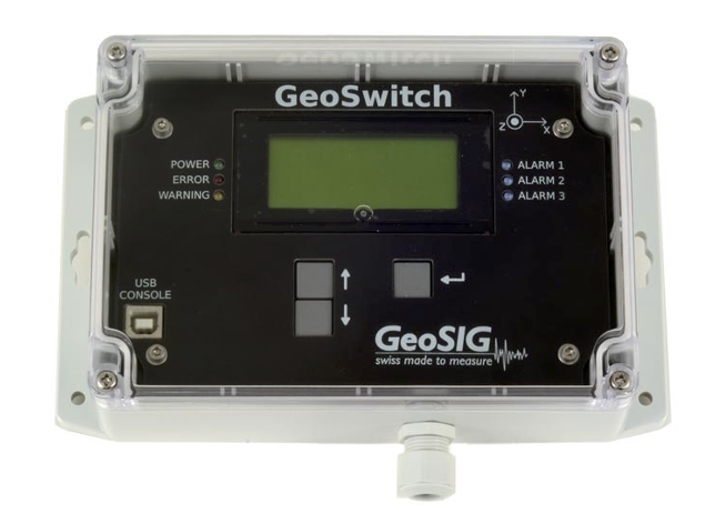
GeoSwitch - Seismic Switch
Product Description
GeoSwitch is packed with many dominant distinctive features offering approvingly reliable protection for people, critical assets, devices and industrial processes. Delivering highly accurate detection of a strong earthquake or structural vibration with various safe shut down options. GeoSwitch has a broad range of applications such as Industrial Processes, Chemical Processes, Gas Valves, Hazardous Systems, Solenoids, elevators, walkways, Electronic gates and doors.
GeoSwitch provides a complete seismic switch system including four rugged triaxial accelerometers organized in GeoSIG RQM™ format and a digital threshold detection circuitry for up to three independent switch levels, output relays, and power backup. GeoSwitch is housed in a versatile industrial rated enclosure with a single cable inlet for all connections.
Ideally suited for accurate monitoring of strong ground motions to control relay contacts at different acceleration levels for warning and/or alarm functions the GeoSwitch provides user programmable set-points over the full measuring range available. Key features of the GeoSwitch include a wide selection of secure user interaction options including the built-in on demand Bluetooth, or the hardware ports of USB and serial MODBUS. The USB console interface conveniently located under the transparent hood of the unit provides the simplest installation and maintenance under any condition using the GeoSwitch Configurator™ software.
Key Features
- Three independent seismic relays.
- Seismic event and equipment fault alarms.
- Redundant Quadruplet Matrix (RQM)™ of triaxial MEMS accelerometers.
- Internal maintenance-free power backup.
- Non-battery power autonomy.
- Optional internal LiPo battery for more than 36h autonomy.
- Intuitive LCD display and LED indicators.
SMS / SAS
Product Description
The SMS/SAS systems are mostly used in Nuclear Power Plant or other Industrial Facility Seismic Monitoring Projects. If you need any further specific information, please do not hesitate to contact us through our agent assigned for this kind of instrumentation for your geographical region or directly.
The core of the SMS / SAS is a Central Processing Unit (CPU) with a multi-channel digital recorder system rack mounted in an industrial cabinet together with an industrial computer and relevant peripherals. Accelerometers, seismometers, complete seismic stations or sensor packages, which are referred to as Detection / Recording Units (DRUs), are placed at remote locations and can be connected to the CPU.
The system has been designed in a way that it is not bound to a single topology. There could be only the sensors or both sensors and data acquisition out in the field. Advantages of these topologies are briefly explained in the specifications section.
The system has great modularity and flexibility to simplify an instrumentation upgrade and enable existing elements to be reused as much as possible. The system provides added reliability with built-in redundancy of the recorders and power supply, continual SOH software checks, alerts transmitted to multiple sources, and a choice of data back-up. The PSU has quadruple redundancy of the sources. All calculations take place on each recorder, so the PC (CPU) has no critical impact on calculation and analysis of exceedances.
The CPU monitors all DRUs in parallel, as a result of the dedicated communication links that are provided by the system hardware.
Key Features
- Recording, advanced analysis and annunciation according to project specific or international regulations .
- Automatic exceedance evaluation.
- Reporting and alerting via relays, visual and audible tools as well as printed matter .
- Up to 36 remote triaxial analog sensors and unlimited number of seismic field recorder stations.
- 24 to 32-bit event based and/or continuous recording .
- Common timing and triggering within the system .
- Completely over-voltage protected.
STS
Product Description
STS is a state-of-the-art seismic switch / trip system packaged as a 19’’ rack module consisting of Slot-in Modules (SiMs) inserted into vertical slots with a remote accelerometer connected to it. It provides a set of highly reliable alarm contacts as outputs activated by exceedance of acceleration and/or based on state of health.
The STS combines the best of the analog and digital technologies by utilizing only hardware for the highly reliable alarms, and digital data acquisition for realtime digital monitoring, recording, playback, in-depth processing and archiving of the sensor signal. The unit provides full traceability of the sensor signal as well as the system logs, even if no trip was activated; with a buffer spanning to several weeks back. All of the digital information can also be provided to remote users in real time, on demand, continuously and/or periodically.
Applications include:
- Automatic Seismic Trip System (ASTS)
- Detectors for integration in an ASTS
- Connection to an emergency shutdown system
- Nuclear Reactor protection
Key Features
- High reliability by using only analog signal and hardware for the trip signal.
- Field proven GeoSIG accelerometer.
- Trip on any individual sensor axis or on any vector sum of axes.
- Highly flexible analog filtering for the sensor signal to fit project requirements.
- Testable analog full chain from sensor up to alarm output.
- Permanent monitoring of the connection to the sensor.
- Easy maintenance and simple troubleshooting with rich number of test points and indicators.
Software
GeoDAS
Product Description
GeoDAS is a graphical Microsoft Windows-based application. It provides the most comprehensive, intuitive and versatile features available in the earthquake, seismic, structural, dynamic and static monitoring and measuring industry. Fundamentally the program is used for instrument configuration and for acquisition of data provided by any standard GeoSIG instrument.All recent Windows versions are supported, down to Windows 7.
The GeoDAS-COM package includes the GeoDAS-BASE package and specific basic cables and hardware certified to use with the relevant equipment supplied. The Data Analysis part of GeoDAS (GeoDAS-DAP) has been developed by GeoSIG especially for the strong motion, earthquake engineering and civil engineering data analysis.The following operations can be performed:
- Lowpass Filter
- Highpass Filter
- Baseline correction
- Integration
- Differentiation
- Vector Sum
- Cumulative Absolute Velocity (CAV)
- Time-domain Filtering
- Effective Values
- Damping
- Power Spectra
- Strong Motion Data Processing
- OBE / SSE Event Checks
- Support for ADC Boards
- Static Measurements
- Automatic Event Processing
- Automatic File Conversion
Key Features
- Instrument setup to change any configuration parameters of any instrument(s).
- State of Health (SOH) monitoring for permanent or periodical monitoring of instrument/system status.
- Downloading of the event files from recorder(s).
- Real-time data viewer and recorder for instrument(s) providing data streams.
- Off-line data viewer.
- Convert/Export to ASCII, SUDS, SAC, SEISAN, ARTeMIS, MATLAB.
- Logger features to store important system messages in a log file.
- Station Map.
- Network Monitor .
- Network Links .
- Messenger.
- Statistics of Communications.
ARTEMIS
Product Description
The ARTeMIS software range is an effective tool for modal identification of civil engineering structures such as buildings, bridges, dams and offshore structures. The software allows the user to accurately estimate natural frequencies of vibration and associated mode shapes and modal damping of a structure from measured responses only.
In all versions of ARTeMIS, one can generate geometric information and perform measurements in any standard measurement system, then perform modal identification and validation. Response data files can be provided in a flexible ASCII format or by making use of the standard Universal File Format (UFF).
All versions include powerful and efficient signal processing tools, capabilities for 2D display of spectral densities and correlation functions, and for 3D geometry validation and mode shape animation. All plots and tables can easily be exported to other Windows programs such as Word and Excel using copy/paste commands. This also helps produce credible documentation with a minimum amount of work involved.
Key Features
- The 4W-drive of Modal Analysis.
- It takes you anywhere in Modal Analysis easily and does it well.
- Large structures, micro structures, operating structures.
- No shaker, no lab, no test rig.
- Real boundary conditions, real MIMO.
- Take Modal Analysis in the field.
SEISAN
Product Description
SEISAN analysis software suite is a complete set of programs and an uncomplicated database for analyzing earthquakes from analog and digital data, by University of Bergen. GeoSIG’s software GeoDAS can automatically link to an existing SEISAN database and can automatically provide all retrieved data from all configured stations into this database in a directly useable format. The system consists of a set of advanced seismic analysis programs operating over a seismic database.
With SEISAN it is possible to use local and global earthquakes to enter phase readings manually or pick them with a cursor, locate events, edit events, determine spectral parameters, seismic moment, azimuth of arrival from 3-component stations and plot epicenters. Using the search programs it is possible to use different criteria to search the database for particular events and work with this subset without extracting the events. Additionally, SEISAN contains some integrated research type programs like codaQ, synthetic modeling and a complete system for seismic hazard calculation.
The smallest basic unit of the database is a file containing original phase readings (arrival times, amplitude, period, azimuth, and apparent velocity) for one event. The name of that file is also the event ID, which is the key to all information about the event in the database. Although the database in reality only consists of a large number of sub-directories and files (all of which the user has access to), the intention is that by using the surrounding software, the user should rarely need to access the files directly, but rather do all work from the user's own directory. Test data and a tutorial are supplied with the suite.
Key Features
- Epicenter/Hypocenter location .
- Trace plotting, phase picking and spectral analysis.
- Plotting epicenters.
- Searching in the database.
- Extracting events from the database.
- Reports and statistics.
- Waveform file management.
- File conversion and modification.
- Signal processing.
- Calculating b-value.
GeoSMART
Product Description
GeoSMART is an innovative graphical Java-based application that provides tools for realtime structural health monitoring for civil engineering structures. GeoSMART, with its "smart" features, can monitor and display the status of a structure that is equipped with GeoSIG measuring instruments.
GeoSMART is S2HM in a Box; it has been designed to meet fundamental engineering requirements with respect to structural health monitoring applications.
The main features of GeoSMART can be summarized as follows:
- Configuration based on a simple ASCII text file where all parameters and settings are defined.
- Plots a 3D model of a structure consisting of lines and surfaces.
- Connects to and receives near-realtime data from GeoSIG instruments which send GSBU streams.
- Organizes and plots the incoming streams as synchronized waveforms.
- Monitors the incoming streams against exceedance of 4 predefined levels and notifies user with visual indications (optional hardware relay activation through the serial port of the computer is available).
- Calculates and plots frequency content of desired incoming streams.
- Calculates rigid body translations and rotations on the X - Y plane.
- Calculates interpolated rigid body motions of non-instrumented bodies based on instrumented ones.
- Animates the translational and rotational motions of the 3D model.
- Plots interstory drifts and rotational differences as synchronized waveforms and in relative planar view.
- Monitors the interstory drifts and rotational differences against exceedance of 4 predefined levels and notifies user with visual indications (optional hardware relay activation through the serial port of the computer is available).
- Continuously saves incoming channels, interstory drifts (including rotational differences), frequency content and response spectra into ASCII text files which can be opened using GeoDAS software (or any other software that can process ASCII files).
- Replays previously recorded file instead of realtime streams.
Key Features
- Provides intuitive and fully controllable configuration based on a simple ASCII text file where all parameters and settings are defined.
- Plots 3D model of "any" user defined structure utilising lines and surfaces with interactive zoom, camera view-point, rotate, pan and color options.
- Connects to and receives near real-time data from GeoSIG instruments which send GSBU streams.
- Organizes and plots the incoming streams as synchronized waveforms.
- Provides notifications as color coded text messages and color changing indicators on screen; if desired via emails, and optionally through hardware relay activation (on/off signals to start or shutdown any process) through the serial or USB port of the computer.
- Monitors the incoming streams against exceedance of up to 8 (eight) predefined threshold levels and notifies user in case of exceedance.
- Calculates and plots sliding window based frequency content of desired incoming streams.
- File conversion and modification.
- Calculates and plots sliding window based frequency history (spectrogram) of desired incoming streams.
- Calculates and plots sliding window based response spectra of desired incoming streams.
Communication
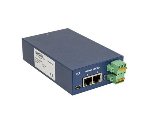
ETH-LLAN Ethernet Module
Product Description
The ETH-LLAN utilizes the SHDSL technology which allows data transmission at speeds up to 15 Mbps over a single twisted pair of copper wire. In addition, ETH-LLAN supports DSL channel bonding for up to 2 copper pairs in order to achieve speeds to 30 Mbps.
An integrated 2 port 10/100BaseT Ethernet managed switch with enables the use of your distributed networked devices over simple, cost efficient, and site friendly copper cabling.
Combination of this quality with comprehensive functions providing maximum flexibility makes the ETH-LLAN the most efficient long distance cable link solution between any GeoSIG instrument or computer.
ETH-LLAN design is based on high grade industrial components and it is manufactured according to highest quality standards.
Key Features
- 5.7-15 Mbps over single twisted pair copper cable.
- SHDSL and SHDSL.bis, 3 km or more.
- Channel bonding for up to 2 pairs.
- Point-to-Point, Point-to-Multipoint, Add/Drop, Ring applications.
- Integrated 2 port Ethernet switch.
- Robust metal housing.
TEL-WLx Wireless LAN Communication System
Product Description
GeoSIG's TEL-WLx Wireless LAN Communications System offers versatility and ease of use in a variety of locations and applications.
TEL-WLx allows combining a number of field stations to one single network, which feature easy data acquisition and maintenance. The authorized user has access to the data from every node inside the network. Additionally it is possible to change the settings of every field station and the equipment attached to it from a remote location. At the same time the network is fully protected from unauthorized access by WEP encryption.
In point to point mode wireless connections up to 30 km arve possible. If the distance is shorter point to multi point configurations are possible.
GeoSIG is able to assist its customers in finding the right equipment for their project as well as in the evaluation of potential telemetry links. Global terrain data allows GeoSIG to calculate line of sight profiles anywhere around the world.
Key Features
- 2.4 GHz operation.
- Protected WLAN Network.
- Up to 30 kilometre operating range.
- Point to point / Point to multi point.
- Weather resistant enclosure.
- Easy connection and wiring.
GXX-4GMX Series 4G Router
Product Description
The GXX-4GM series are 4G routers which provide a secure wireless connection using the 4G network infrastructure for high speed data communications. The GXX-4GM is a Multi-Band module solution with HSPA as well as GSM/GPRS/EDGE with up to 7.2 Mbps for downlink data transfer. The 4G router can be delivered either as an external module, connected to and powered directly from GMSplus series recorders or as stand-alone module for use with a computer or any other Ethernet compatible device. The unit is delivered with all necessary accessories, and peripheral units such as the cabling, connectors, antenna, etc as well as firmware & software, thus is ready to use out of the box together with the associated GeoSIG solution.
Key Features
- HSPA & Quad Band GSM, upto 7.2 Mbps download.
- 10/100 Ethernet and USB interface.
- N-type connector for external antenna (GXX-4GM).
- High speed wireless network support.
ETH-FLAN Ethernet Module
Product Description
The ETH-FLAN provides conversion of FO to copper Ethernet, which allows high speed data transmission. An integrated 10/100BaseT Ethernet switch enables the use of your distributed networked devices over a FO cable. ETH-FLAN design is based on high grade industrial components and it is manufactured according to highest quality standards. ETH-FLAN is an efficient long distance cable link solution between any GeoSIG instrument or computer.
Key Features
- 100BaseFX and 10/100BaseT(X) ports.
- Converts copper Ethernet to FO.
- Up to 4 km or more in multimode operation .
- Point-to-Point, and Ring applications.
GXX-4GUE Series 4G Modem
Product Description
The GXX-4GU series are 4G modems, which provide a secure wireless connection using the 4G network infrastructure for high-speed data communications.
The GXX-4GU is a Multi - Band module solution with LTE - FDD / LTE - TDD and HSPA+ as well as GSM / GPRS / EDGE with up to 150 Mbps for downlink data transfer.
The 4G modem can be delivered as an external module, connected to and powered directly from GMS series recorders.
The unit is delivered with all necessary accessories, and peripheral units such as the cabling, connectors, antenna, etc. as well as firmware & software, thus is ready to use out of the box together with the associated GeoSIG solution.
Key Features
- Multi-Band LTE / HSPA+ and GSM / GPRS / EDGE.
- High speed wireless network support.
Accessories
SEN-JB-GMS
Product Description
The sensor junction box SEN-JB-GMS for GMS increases the flexibility of GMS-based systems in terms of topology. The internal DC-DC converter provides a stabilized and insulated 15 VDC supply to the sensor(s), allowing for sensor cable lengths up to 1000 m.
Furthermore, the SEN-JB-GMS can be used to combine uni- and/or bi-axial sensors on one connector of the GMS series. Full overvoltage protection and an IP66 watertight housing make it a valuable accessory for any GMS based measuring or monitoring system.
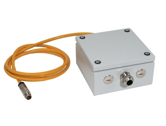
Key Features
- Junction box to allow for cable of up to 1000m sensor cable length .
- Full over voltage protection.
- Incl. stabilized and insulated 15 DVC supply to sensor.
- Suitable for up to 3 channels .
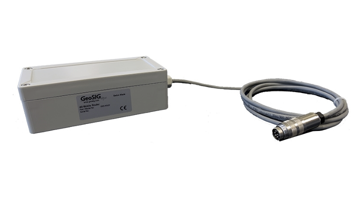
GMS-GPS
Product Description
The GMS-GPS is a state of the art GPS receiver module which employs U-BLOX NEO-M8N that is a complete GPS receiver and embedded antenna designed for a broad spectrum of system application.
The NEO-M8 module is concurrent GNSS receiver which can receive and track multiple GNSS systems: GPS, Galileo, GLONASS and BeiDou. Its far-reaching capability meets the sensitivity requirements of seismic applications and low power consumption.
The NEO-M8N design utilizes the latest technology and high level circuit integration to achieve superior performance while minimizing space and power requirements.
The GMS-GPS is housed in a water-resistant case and designed to withstand rugged operating conditions. The host system may communicate with the GMS-GPS via a dedicated, compatible, bi-directional communication channel. Internal memory backup allows the GMS-GPS to retain critical data such as satellite orbital parameters, last position, date, and time.
Key Features
- Concurrent reception of up to 3 GNSS (GPS, Galileo, GLONASS, BeiDou).
- Supports all satellite augmentation systems and Assisted GNSS (A-GNSS).
- 30 nanosecond time accuracy (RMS).
- 2.5 m position accuracy GPS.
- Rugged, water resistant housing.
Solar Power Solution
Product Description
The system comprises solar panels, charger/regulator, batteries and a mounting kit. Please note that solar components are frequently changed/improved by the manufacturers, therefore the context of the product document is to provide an overview of typical characteristics. Depending on the particular system supplied, the components may differ from the ones shown.
The size of the solar panel depends on the power requirements of the installed GeoSIG components.
In addition we consider additional factors as the geographical location, environmental conditions, your project design and autonomy requirements. Based on this information we calculate the optimum system capacity and design suitable solar power solution for each site and system.

Key Features
- Field proven design.
- High reliability and flexibility.
- Solar power solutions that are suitable for harsh environmental conditions.
- Secure housing for all environments .
Downhole Tube
Product Description
Aluminum inclinometer casing (tube) is a special grooved tubing, generally installed within a drilled hole, used in conjunction with a wheeled sensor probe system to determine sub-surface ground dynamic movements. Its internal grooves provide an orientation reference for the inclinometer probe readings. During manufacturing particular attention is paid to minimize the twisting of the casing grooves.
The casing is inserted section by section in a drilled hole with a settled PVC tube of at least 100 mm inner diameter. The casing is supplied in sections of 3 meters long and a coupling element is used to assemble the whole casing at installation time. The assembly is done using "pop" rivets and each coupling is sealed with tape. At the bottom of the tube, a cover is mounted to seal the tube. Sealing is needed for the time until the sensor is placed into the casing. After complete casing insertion, it must be settled in the hole using a light concrete mixture. Then the sensor can be inserted and fixed in position after it has been tested for some time. The sensor is guided by a set of wheels mounted bellow it (see figure on the left). The wheels are guided by the grooves inside the inclinometer casing all along its length. Before inserting into the casing, the sensor orientation should be adjusted relative to the casing.
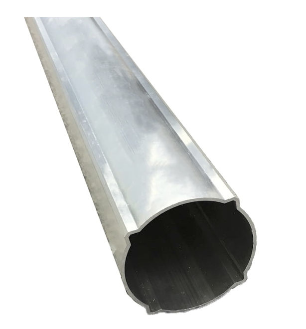
Key Features
- Aluminum Tube Casing to utilize for downhole applications.
- 3 m long sections for boreholes of ∅ >100 mm.
- Special grooved cross-section in compliance with wheeled sensor probe system.
BAT-Exxx Power Module
Product Description
BAT-Exxx power module consists of GeoSIG Power Pack as well as an external battery inside a marine housing. The module is supplied with necessary cables for inter-connection and to connect to relevant equipment. The Power Pack contains a power supply and a charger specially designed to provide constant power to the GeoSIG instruments and charge an external lead battery.
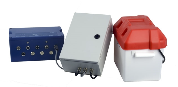
Key Features
- Power supply and charger.
- External batteries.
- Field friendly terminal connectors.